
by Philip S. Prince, Virginia Division of Geology and Mineral Resources
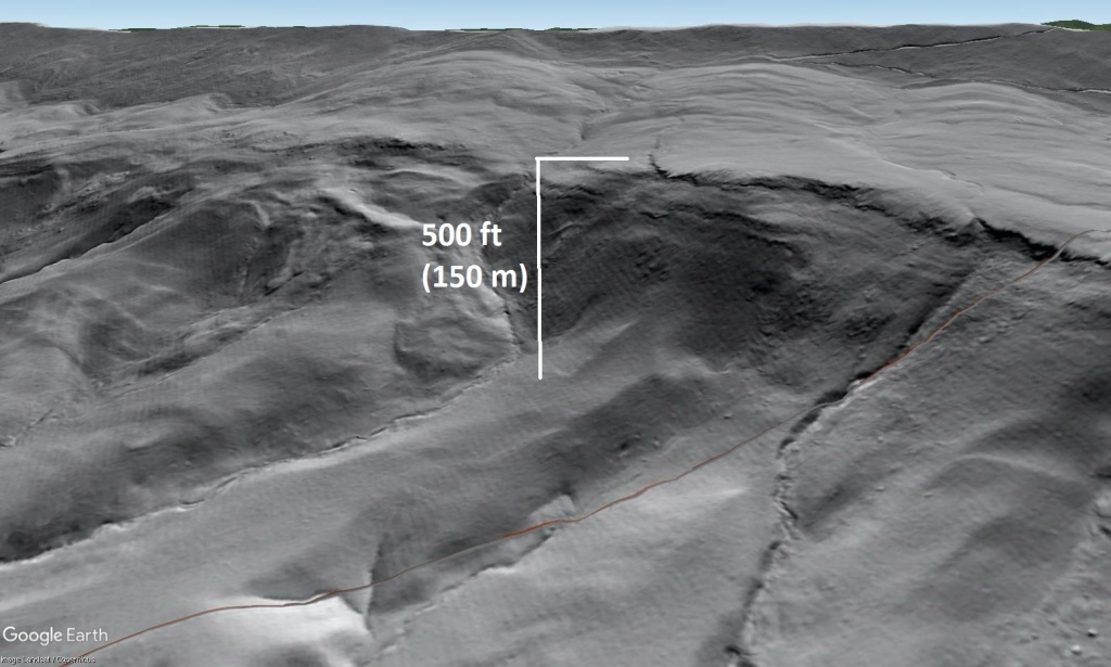
The southeast slope of Sinking Creek Mountain in Craig County, Virginia hosts what is certainly one of the largest landslide complexes in eastern North America–and possibly the least noticeable. Despite extending for 15 miles (25 km) along the mountainside, displacing 500 foot (150 m) thick slabs of rock up to 2,000 ft (600 m), and being located only 30 minutes from Virginia Tech in a populated area, this group of translational blockslides (rockslides that did not break apart) was not documented until 1986 by Art Schultz of the USGS. The size and extent of the slide complex is actually the reason it was able to escape notice for so long. Its features are so large and extensive that no position on the ground offers a vantage point to compare an intact portion of the mountainside with an area affected by sliding. Vegetation, of course, does not help either. The only evidence of these slides that is apparent to a ground observer is a low and subtle line of foothills beneath the ridge crest of Sinking Creek Mountain.
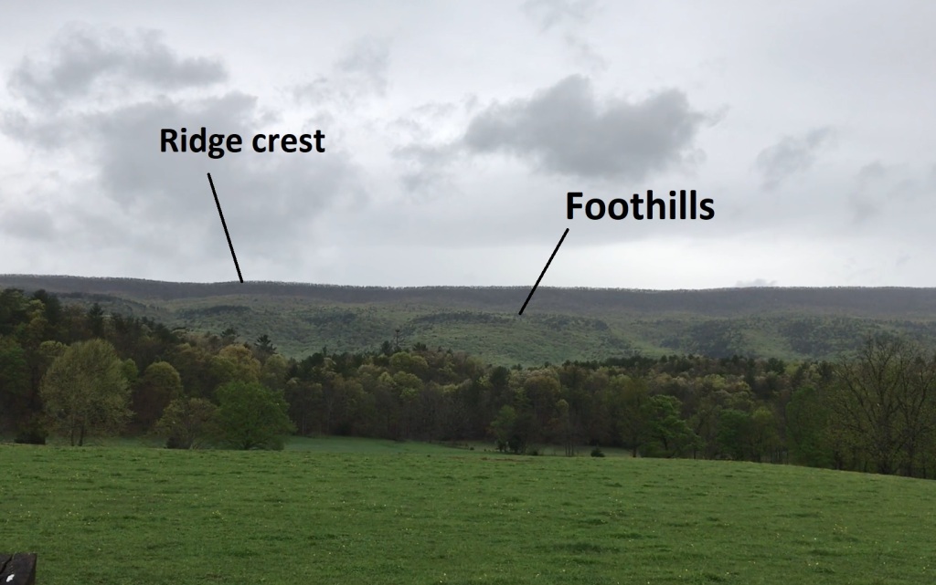
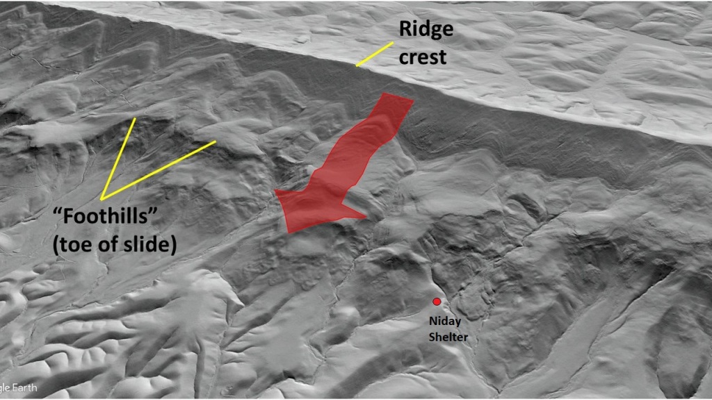
The foothills are actually the toe of the slide mass, but their size, extent and appearance makes them look like a feature related to erosion of compressionally folded and faulted sedimentary layers, just like all of the surrounding ridges. As with most aspects of Appalachian landscapes, a LiDAR-based hillshade is very useful in making the true context of the foothills easier to see. In effect, the whole side of the mountain detached as large blocks and slid downhill, which is apparent in the image below. Even before this imagery was available, the slide complex generated enough interest to produce three papers and a US Forest Service pamphlet. In this post I hope to expand on these documents with the new 1-meter imagery, a few sand models, and my own experiences conducting 1:24k quadrangle mapping in the slide zone.
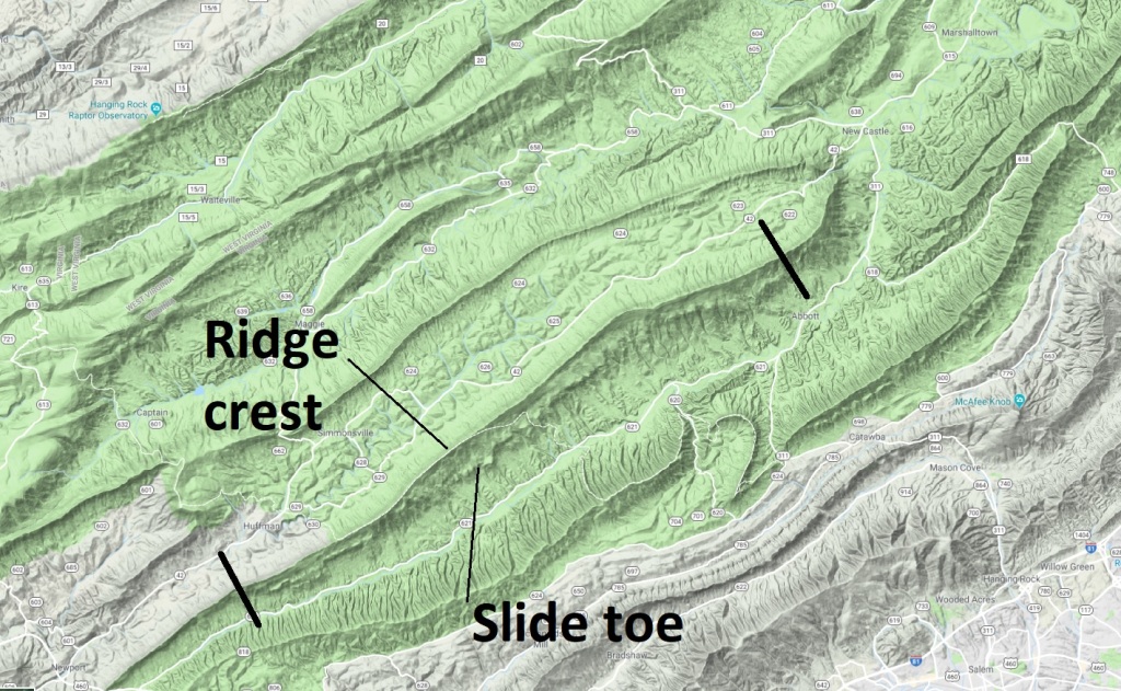
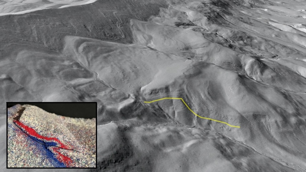
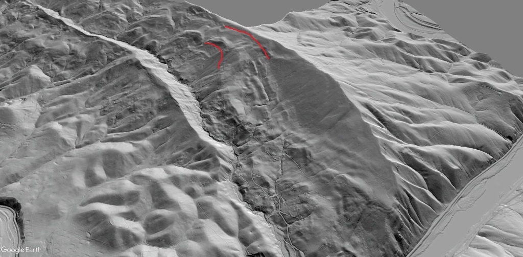
Schultz demonstrated impressive insight in identifying the slide complex in pre-digital topography days due to its extent and confusing field expression. Because the slide blocks are intact slabs of Silurian sandstone layers up to 500 feet/150 m thick, there are measurable rock outcrops in the foothills that look like intact bedrock but dip in an unusual direction–back towards the slope, instead of downhill like one would expect on a dip slope ridge. This orientation is clearly visible in the hillshade:
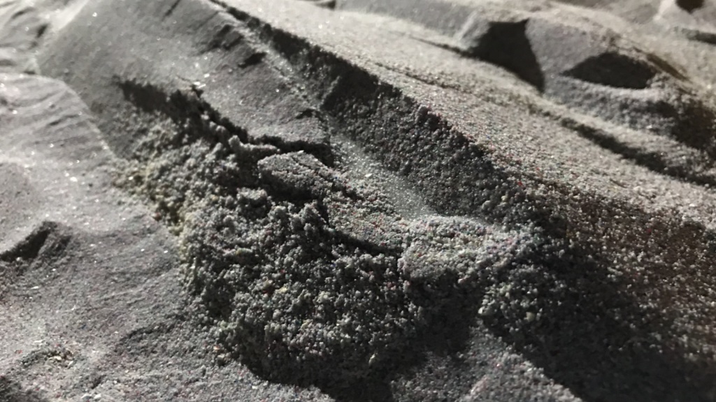
In several locations, the sequence of oddly dipping layers is positioned atop younger Devonian shale in an arrangement that suggests compressional thrust faulting, which would be very much expected in the Virginia Valley and Ridge. Schultz recognized that this atypical trend in “foothills” layer orientations did indeed develop through compressional deformation; it just happened on the downhill end of massive blockslides instead of during thrust belt development. The following video attempts to put the process in motion, and also introduces a nearby slide feature that is discussed at the end of the post. In the cutaway of the slide model, note how the red layers tilt gently back towards the slope on the uphill side of the toe fold.
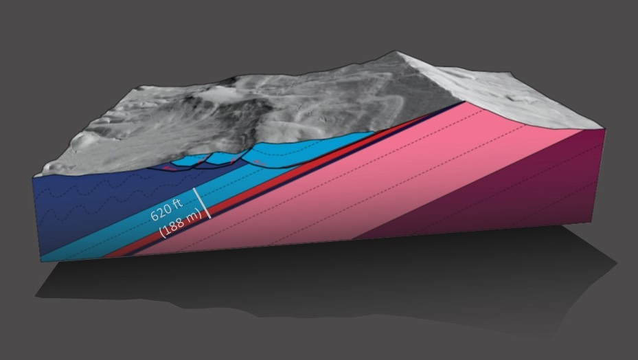
Because these huge slides involve so much intact rock, they have to be dealt with in geologic cross sections of the area. Orientation data of outcrops on the slide masses is plentiful, and rock layers involved in the slides are sufficiently recognizable to generalize a cross section through a given portion of the slide with the aid of LiDAR imagery. These cross sections can be more than simply conceptual, but drawing them to be restorable would be effectively impossible due to lacking information about deformation of the slide during its movement and post-sliding erosion, among other things. Below, I have attempted to make a reasonable (but not restorable!) cross section and block diagram through an interesting part of the slide complex. In this specific area, the sandstone slab underwent further slumping and sliding after it slid up and onto the Devonian shale (dark blue, in the valley).

The light blue-red-dark blue Siluro-Devonian package is about 620 ft (188 m) thick, and the slide mass is detached here in the red Rose Hill Formation, a maroon-green sandstone/interbed sequence containing some very weak layers. Movement of the slide is translational in the sense that it failed and slid within the Rose Hill, but its toe ramp (which causes the light blue layers to tilt up towards the surface) is deep-seated and would have been as much as 300 ft (90 m) or more beneath the ground at the time of slide emplacement. No one knows if this emplacement was gradual or a single event that you could have watched from a nearby ridge crest. Schultz discusses this question in a 1993 publication: (https://ngmdb.usgs.gov/Prodesc/proddesc_10258.htm). Regardless of whether emplacement was fast or slow, the physical scale of these slides and how much of them remained intact during movement is impressive.
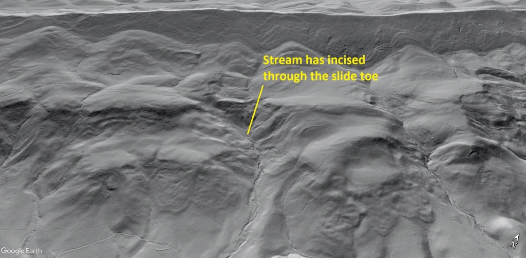
1-meter hillshade reveals some very interesting physical features of the slides that relate to their structural style. Most of the interesting features are visible on the downslope end of the slides, where toe structure and slumping can be observed. These slides are old (no one knows how old) and have experienced significant stream incision since emplacement, providing a cross sectional view of folded layers in the toe in some places.
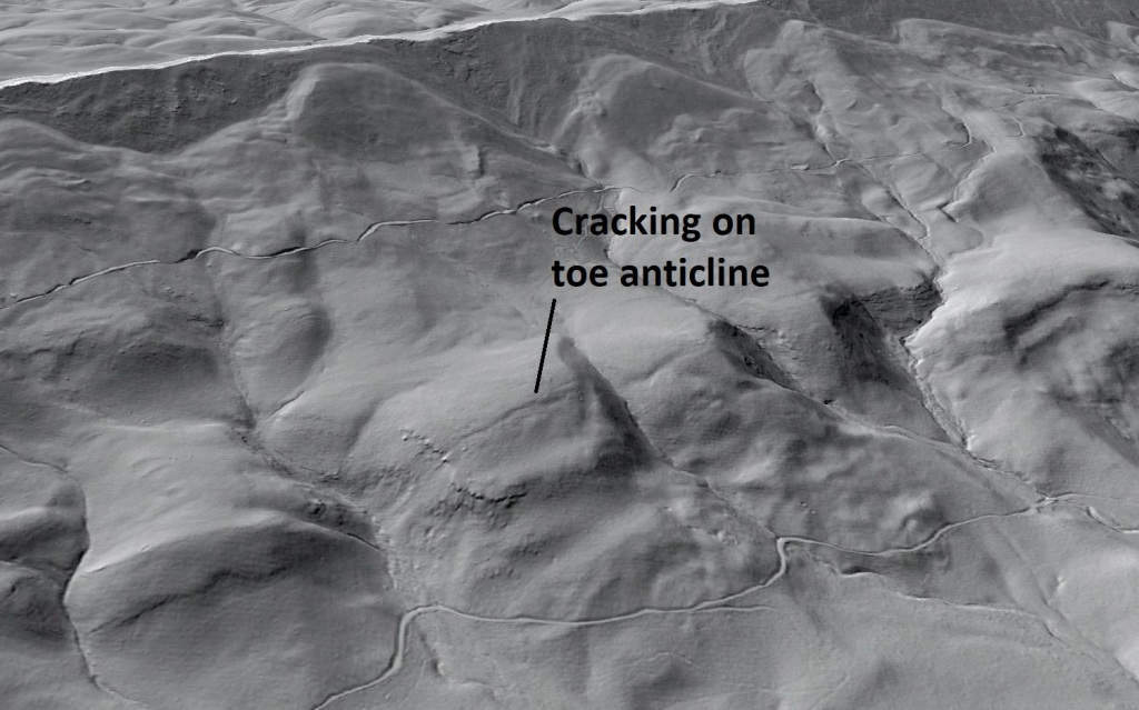
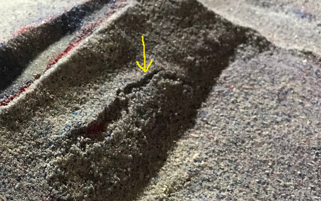
In some areas, the crest of the toe fold began to crack and fail, but stopped short of breaking up or undergoing a large-scale slump. Subtle cracking of the fold crest is visible in the hillshade, and is the same type of feature described in the “slab slide” post back in January. The sand models also develop this type of feature.
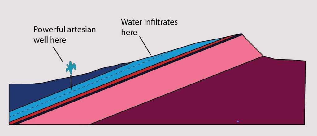
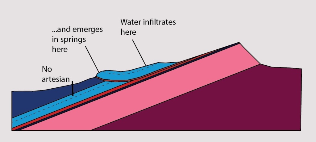
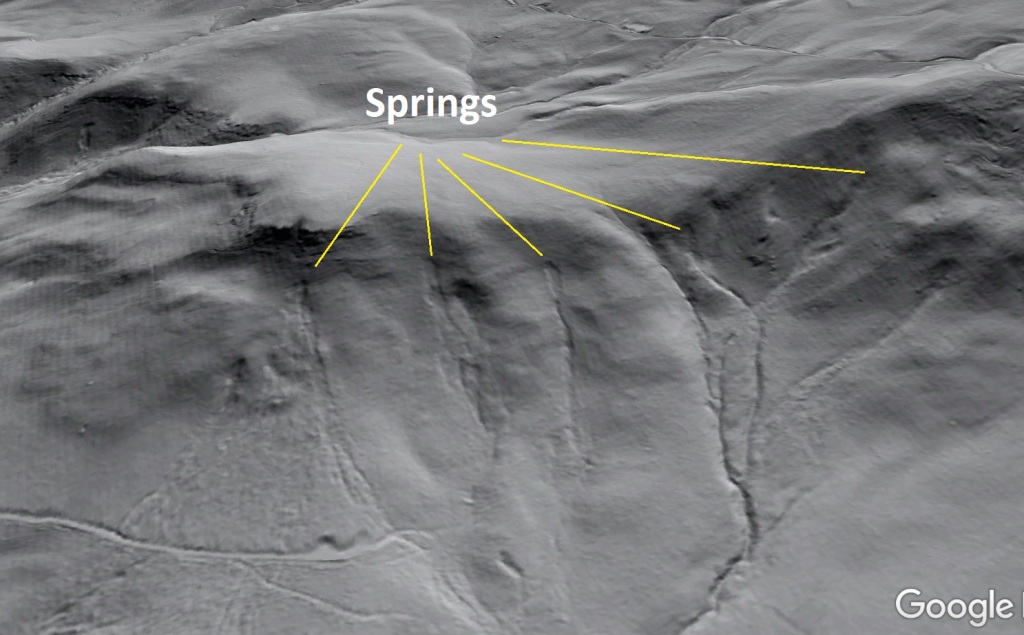
One of the more interesting impacts of these ancient slides is their apparent effect on local hydrology. One of the sandstone layers in the light blue sequence (see the cross sections below) hosts an impressive artesian aquifer on intact portions of the mountain’s southeast slope. Water enters the sandstone bed through its upslope outcrops and remains confined by overlying sandstone layers and the Devonian shale (interestingly, the shale itself does not appear to be the principal seal layer). Drilling into this confined and pressurized aquifer at the foot of the slope yields wells with as much as 20 ft (6 m) of hydraulic head above the ground surface. Hydraulic head is sometimes even greater, and one well became uncontrollable during drilling, leading to rapid depletion of neighboring wells. This interesting and impressive water resource does not appear to be active where sliding has occurred, as the aquifer layer is broken and water that infiltrated upslope “leaks” from the slide toe as impressive springs.
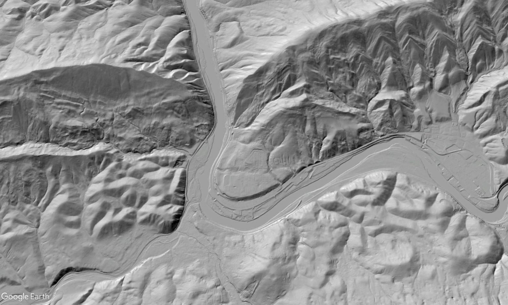
While the Sinking Creek Mountain slide complex is by far the largest in the region, several smaller slides that are still too big to easily appreciate from the ground have occurred within the same rock sequence. East River Mountain above Narrows, Virginia hosts an interesting slide that did not break away from intact layers on its western end. The resulting “hangnail” geometry is apparent in hillshade and matches the last sand model in the video fairly well. This slide was identified by a number of authors during several mappings, but it was always drawn as distinct and fully disconnected blocks because the connecting layering is so completely obscured by forest. Compare the hillshade image and sand model below:
This slide is very apparent when East River Mountain is compared to Peters Mountain, its continuation to the northeast across the New River. The smooth Tuscarora Sandstone slope laid bare by the East River slide is very distinct from the “flatiron” appearance of the Siluro-Devonian sandstone layers still in place on Peters Mountain.
The features are cool to look at, but the big question (and one that motivated Schultz and collaborators; see the 1986 and 1989 papers) is why the slides occurred in the first place. Even though their age is unknown, they demonstrate that the slopes in this part of the Virginia Valley and Ridge at least have the potential to generate some massive slide events that would obviously be hazardous to human life and would cause long-lasting impacts on life in the region. Because of their age, post-slide erosion, and vegetation covering, there really isn’t too much to definitively say about what triggered these features or whether they all occurred at once or over a lengthy interval, but several regional characteristics are worth noting.
The basic nature of the bedrock and associated topography is one significant factor. The weak zones in the Rose Hill Formation underlie a much thicker and stronger sandstone sequence that will develop steep and significant slopes with the energetic potential to produce slides. Topographic relief in the area has increased up to 150 meters or more in “recent’ geologic history (certainly less than 10 million years, and possibly as little as ~2.5 million) due to river incision, so a certain amount of “undercutting” effect of slopes must be considered. I think it’s hard to picture this being a major control on the Sinking Creek slides given their present geometry, but it cannot be completely ignored in assessing these features.
A climatic cause seems more appealing, either in the form of a short-term but unusually extreme precipitation pattern or some expression of pronounced warming and cooling within the Pleistocene. The artesian well scenario is interesting to consider here, as it shows that the orientation of layering and its outcrops routes precipitation from slopes into pressurized downslope aquifers. An unusual spike in pore pressure within this system due to a prolonged precipitation episode might weaken the rock mass to the point of failure, particularly if river incision had already over-steepened the lower slopes. Aggressive and oscillating freeze-thaw patterns during the Pleistocene could also have had weakening or “lubricating” effects, even at the depth of the toe ramp and lower sliding surface.
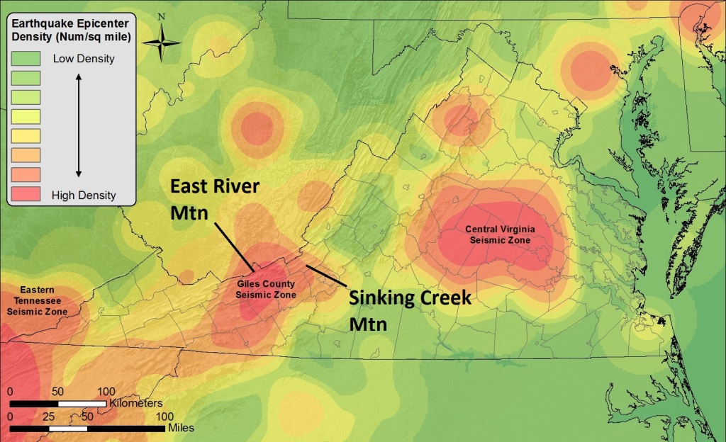
Finally, the nearby Giles County Seismic Zone deserves major consideration. It produced a significant (estimated magnitude 5.5-5.7) earthquake in 1897, and a larger shock impacting the long, narrow topographic ridges in the area might create enough acceleration to cause rock mass failure, particularly if pore pressures were unusually high. Again, the age of the slides, their post-sliding erosion, and lack of sediment storage in the area preclude making a definite association here. It would certainly be an error to exclude a seismic cause, however, as there are a tremendous number of old slides in the Valley and Ridge near the seismic zone, and their density appears to diminish farther away from it. This might also relate to changes in the sedimentary layer package making a slide less likely–who knows?
Regardless of cause, these slides provide an interesting look into landscape history in this part of the southern Appalachians. They also show that moderate post orogenic Appalachian relief is still capable of generating big slope failures. While these features are obviously quite old and show absolutely no evidence of modern activity or creep, they at least show what has happened and raise interesting questions about potential cause!
USGS/Forest Service pamphlet link (Schultz paper references are found on its first page):
