

by Philip S. Prince, Virginia Division of Geology and Mineral Resources
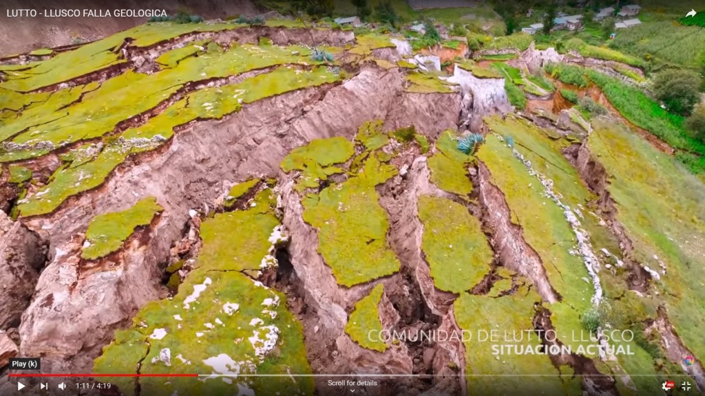
If you Google the word “landslide”…the first search result you get is the Fleetwood Mac song. I suppose this says something about the place of Earth Science in the 2019 world, but whatever (more on this at the end of the post!). Clicking the “Images” tab improves things, assuming you are indeed seeking information about the geologic feature. The very first thumbnail that appears is the Llusco landslide of 2018, which occurred outside of Cusco, Peru, destroying the village of Lutto Kututo (apparently without casualties due to its slow, week-long emplacement). Wikipedia has chosen this feature as the headline image for their “landslide” page, and its striking appearance makes it a good choice.
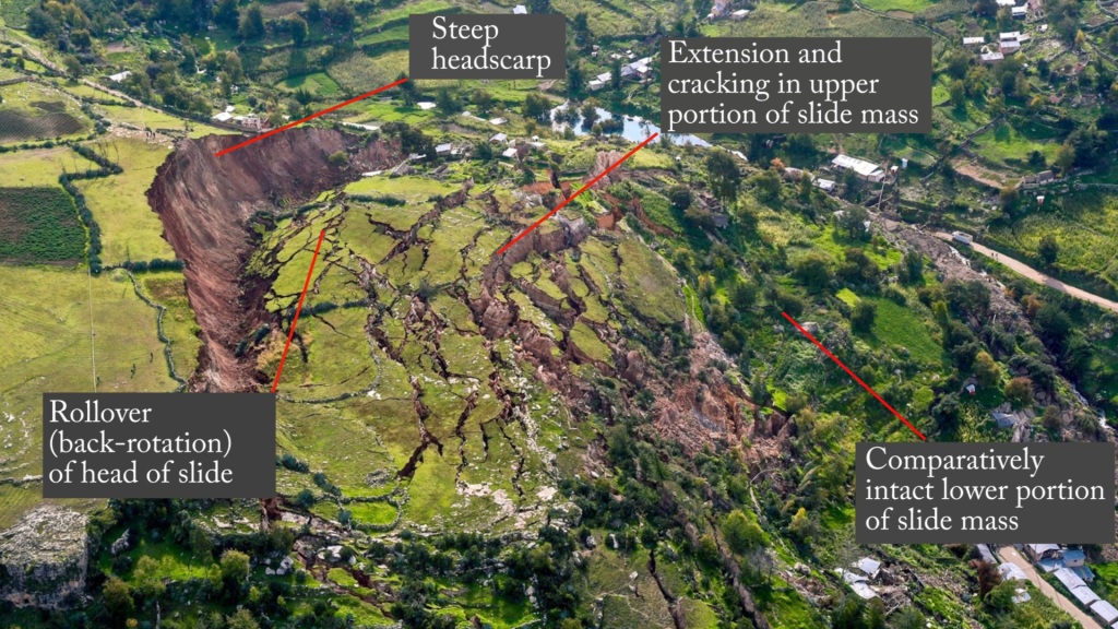
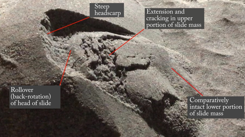
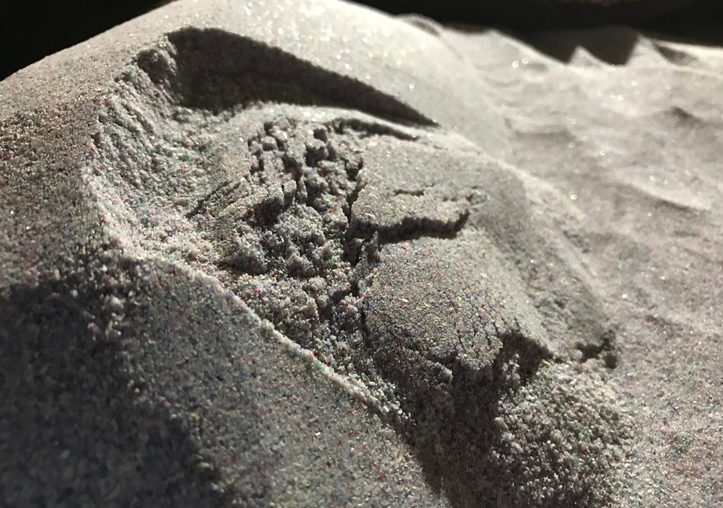
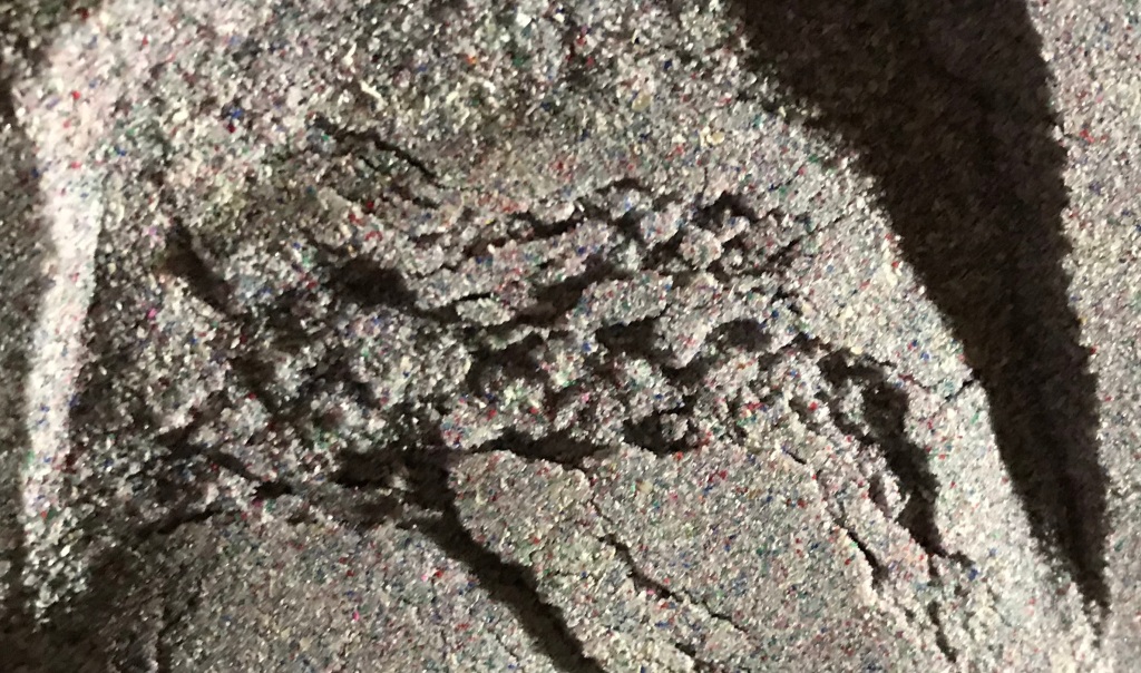
In addition to a very crisp and obvious headscarp, the upslope portion of the slide mass is conspicuously broken into numerous blocks separated by impressive cracks and fissures. I first heard about this slide through Dave Petley’s outstanding Landslide Blog post, which connected the fracturing of the slide mass to the shape of the failure surface. I thought this was a really interesting example of using subsurface geometry and general landslide know-how to explain the very dramatic surface characteristics, and I tried to produce an analog model slide with similar features using moderately cohesive granular media (which means sand with some flour mixed in to make it stickier). The main purpose of the model is to put the rounding and cracking of the upslope portion of the slide into context, as the cracks themselves have made the Llusco slide a very popular feature around the internet (also more on this at the end).
The video linked here shows the model and generally narrates the concepts it illustrates, which are further described below. Note that the model slide is emplaced in a single, rapid event, unlike the real thing (unless it could be considered some version of scaling time down as well as physical size). Even so, the final product shows the appropriate features, which result from controlling the shape of the slide’s failure surface.
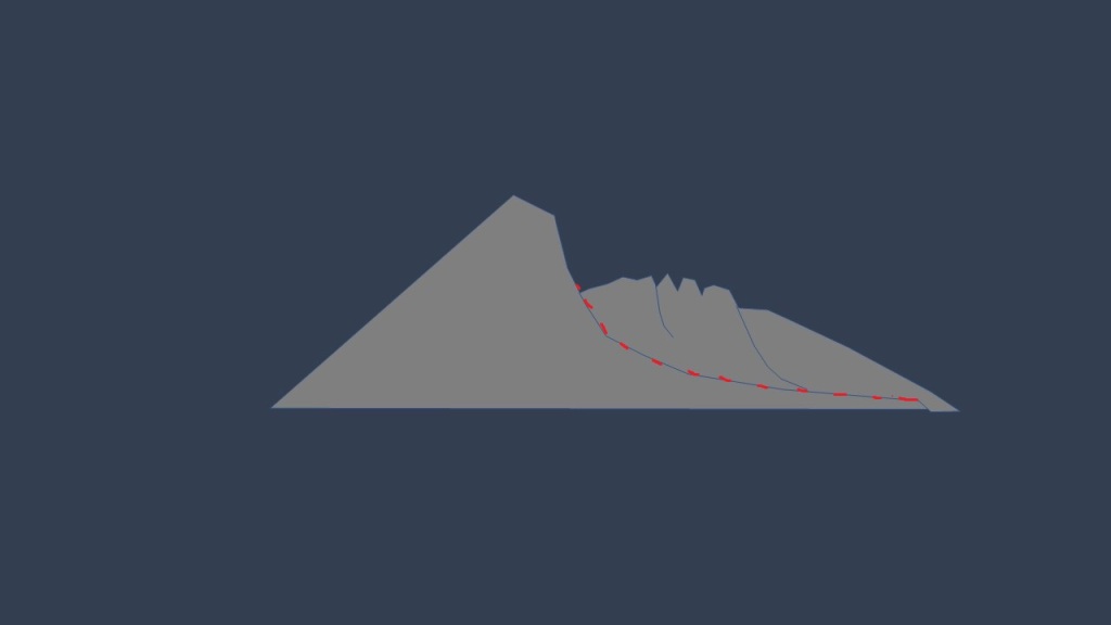
The Landslide Blog post references the non-circular failure surface on which the slide detached and moved. “Non-circular” means the curvature of the failure surface changes along its length; the appearance of the slide suggests the failure surface was strongly curved at its upslope end and much less curved downslope. Accordingly, the bottom of the upslope portion of the slide mass is strongly curved, and when it moves onto the less curved part of the failure surface, the entire upper part of the slide mass must change shape. Fracturing of the top of the slide thus begins. I find reading that confusing and I wrote it, so hopefully the following cross section-style images do a better job.
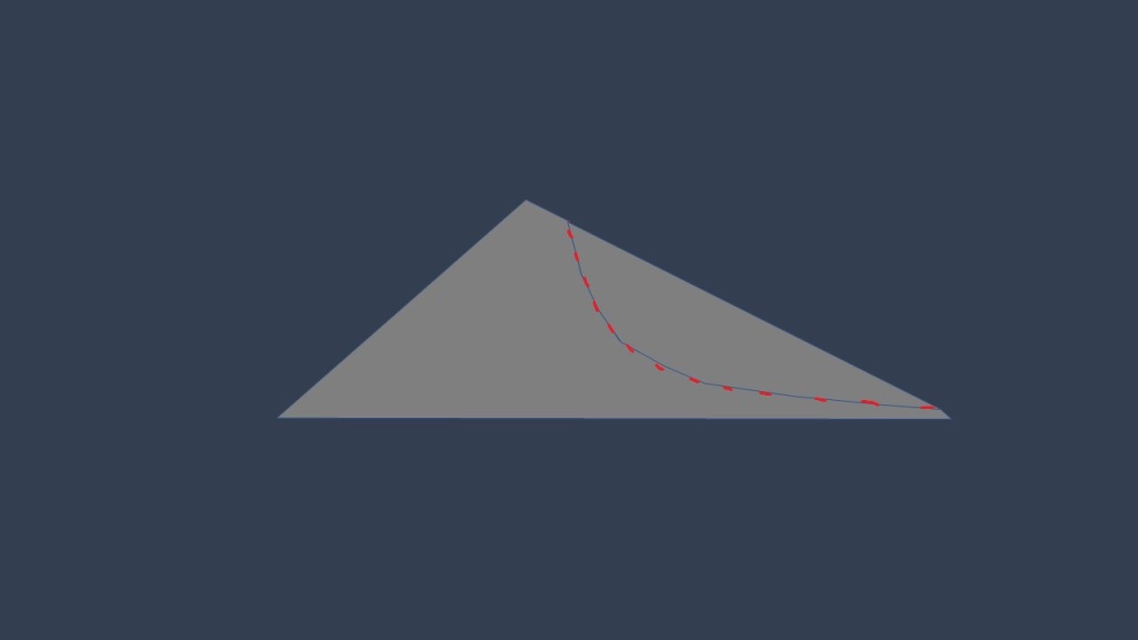
The model slide can be seen to start flexing and cracking just after it begins moving…
Extension and fracturing continue to the point that the slide begins to take on complex characteristics, with its downhill portion starting to move independently of the broken uphill blocks.
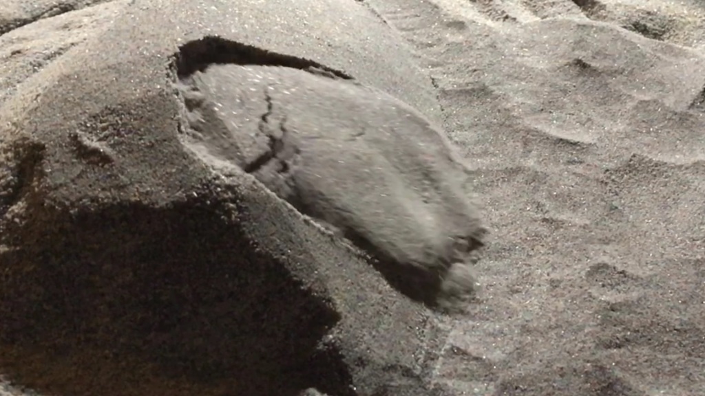
The block-and-fissure portion of the model turned out well, and resembles the general pattern seen in Llusco. Note this requires strong and cohesive model media; as you might imagine, regular dry sand cannot support vertical slopes and blocks of this shape.
The cohesive nature of the model material is also reflected in the steepness of the model headscarp. The head of the slide appears to have back-rotated 30 degrees or more.
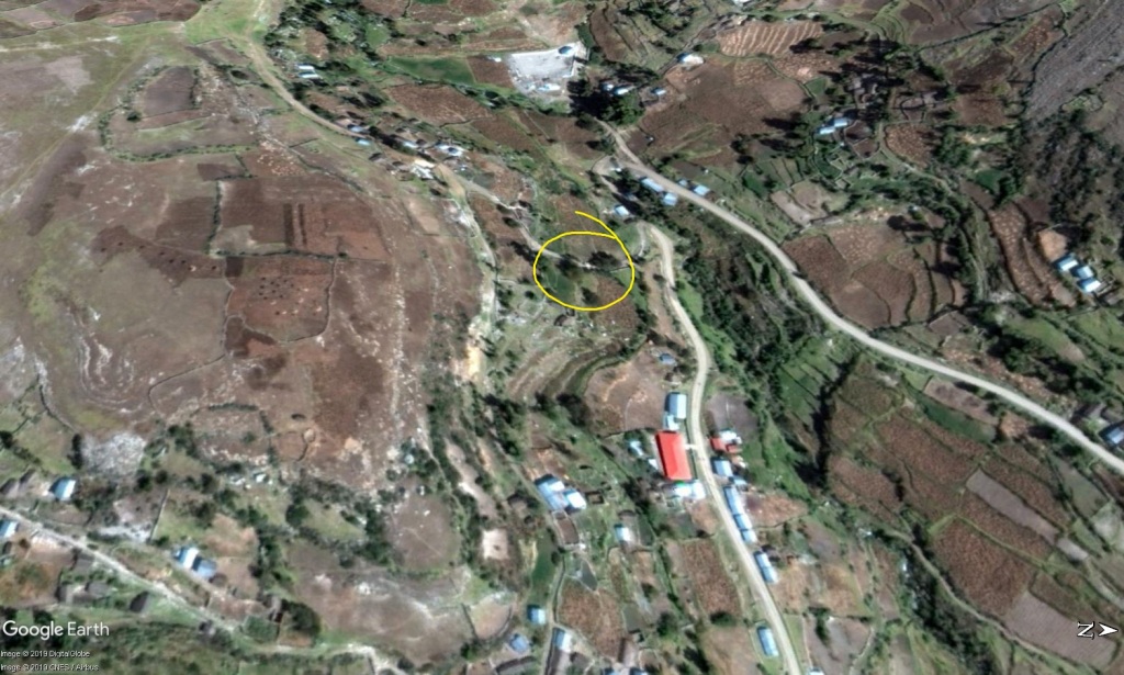
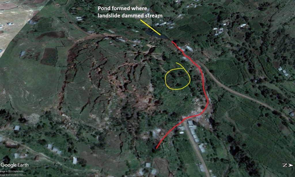
The pictures and video links in the Landslide Blog post are by far the best resources for looking at the actual slide. It’s hard to find on Google Earth, and it is necessary to look at the imagery history to get a good, cloud-free view once you do find it. The March 2018 imagery is pretty good. The slide can be found at 14.390336S 72.109662W. Like the model slide, the fracturing and extension are very intense in the upslope portions of the slide mass. The lower part of the slide, which was presumably situated above a much less curved portion of the failure surface, is comparatively undamaged and its displacement is not immediately obvious until you look at building damage.
Another interesting aspect of the Llusco slide is how many conspiracy theory/fake news/supernatural phenomenon websites picked it up, apparently due to the appearance of the cracks and fissures. I think there used to be even more, as a few links go to deactivated Twitter accounts. The cracks are definitely alarming and eye-catching, but it is important to remember that even the most dramatic expressions of Earth process have rational, and sometimes simple, explanations. I think a major part of creating or accepting the explanation is learning to visualize the overall function of large, slow, or even out-of-sight systems. This is what I try to accomplish with physical models. If you were totally unfamiliar with landslide dynamics or rock mechanics, or if you just saw a single picture of the cracks, it could be very difficult to attribute them to a basic geometric explanation as Dave Petley was able to do in the Landslide Blog post. For me, seeing it all at once makes it easier to work out the cause-and-effect relationships. That said, I somehow doubt that failure surface geometry will ever be as popular as apocalyptic polar reversal frequency change predictions!
